In my last article on the Bowers Building on West Third Street, I mentioned how James H McGee Boulevard was originally created as a widening of what had been Western Ave.
As it turns out, that is an interesting story in its own right which I’ll dig into today.
James H. McGee, the boulevard’s namesake, was the first black mayor of Dayton who served from 1971-1982, the longest tenure of any mayor of the Gem City. He was honored with the street name in 1988 along with a Daytonian who broke color barriers in a much earlier era: author Paul Laurence Dunbar, whose name was given to what had been Summit Street a few blocks away (and where the Dunbar House and museum is located).
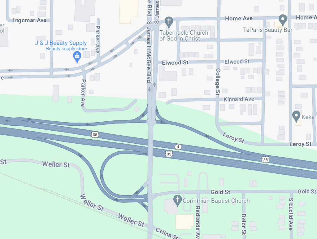
The $11.9 million road project took two-lane Western Ave and widened it into a separated 4 lane road. The new boulevard wasn’t done in isolation but was a key part of a “major upgrading of the transportation corridor in West Dayton” which included a major extension of US-35 to the west and a northwest connector.
The road project was highly touted, connecting west side employment centers including Trotwood, Madison, and Jefferson Twp, and promising to spur economic development that would “create jobs right here in this community for those who live here.”
The City of Dayton made it a priority, calling it “vital to efforts to revitalize West Dayton.”
The push to “extend development north and west toward a very fast-growing area of this community” came at a time when major development followed highway construction in other parts of the region.
The creation of Interstate 675 had “spawned new office buildings near Wright-Patterson Air Force Base” while Dayton officials lamented losing a major development when Elder-Beerman built a distribution center in the south suburbs adjacent to 675 “because of the land shortage and lack of accessibility to a highway network” inside the city limits.
Dayton’s mayor said that “hopefully, U.S. 35 and the Trotwood Connector will do for the northwest part of the county what Interstate 675 did for the south suburbs.”
The city had been working to get the road project built for a staggering 30 years by the time it finally opened. This delay was said to be a major factor in the “slum and blight conditions in parts of West Dayton” from the 1960s to the 1980s.
According to Tom Roberts: “The blight that you see was a direct impact of what wasn’t happening with this highway project. For a long time people didn’t know where the highway was going to go.” Given the prolonged uncertainty during those years, “Why would I put in a building, say, at the intersection of Germantown and South Broadway?”
When the boulevard finally opened, McGee announced “many of us don’t know the importance of such a gateway as this when it comes to the potential for new development.”
But would that potential be realized?
Did the Road Project and 35 West Help or Hurt West Dayton?
It’s been close to 30 years since this “West Dayton highway network” opened. And despite the possibilities for economic development on all the land that was now easy to access, the project didn’t serve as a great equalizer between West and NW Dayton and the south suburbs. The new roads certainly moved more cars through West Dayton faster, but it’s important to look at what happened to the existing neighborhoods.
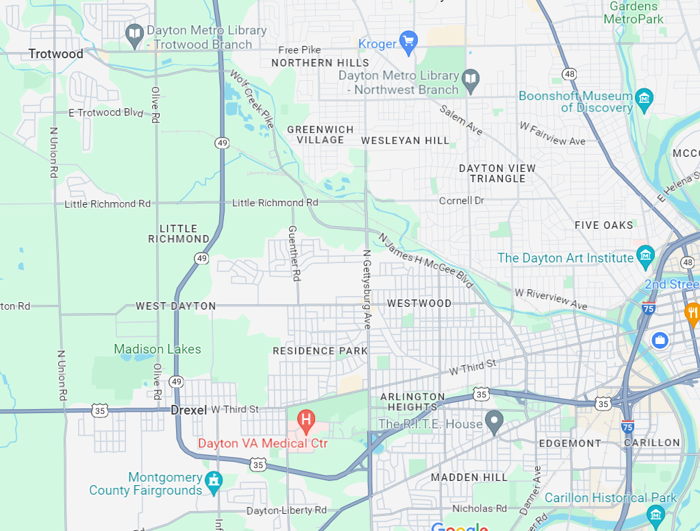
Across the region, manufacturing continued to decline during the 1990s and early 2000s leading to major job losses for the companies already operating in the area. One of the most significant was the Delphi Home Ave plant right next to 35 which closed in 2008 displacing some 400 workers. And commercial developments suffered too. To the northwest, the Salem Mall closed in 2005. New housing developments were indeed built in some parts of Dayton and Trotwood, but some older neighborhoods lost density and shrank at an even faster pace.
It’s unfair and inaccurate to blame the road expansions for these struggles which were caused by everything from national economic trends to a lack of continuing investment in the area.
But there are definitely some important connections.
Highways and Roads Disconnecting Dayton Neighborhoods
In more recent years, the tone from officials has significantly changed. They are now spearheaded projects aimed at “reconnecting neighborhoods that had been divided by infrastructure.”
A planning document for West Dayton states that “Over the last 20 years, West Dayton lost density, residents, businesses and buildings along many of the traditional corridors which left significant gaps.” Germantown Street is the corridor that emptied out the most, according to the document: “Germantown’s purpose shifted after the opening of U.S. 35, resulting in significant disinvestment.” 35 West also runs roughly parallel to West Third Street, which outside of the well-preserved Wright-Dunbar Business District had seen entire blocks empty out and get razed.
One article stated that “the highway basically split West Dayton in half, which made it challenging for residents to travel between the northern and southern parts of the community.”
A potential solution is a pedestrian bridge over 35 at Abbey Avenue connecting residents to the new Dayton Metro Library West Branch and where the historic Wright Company Factory may soon see redevelopment.
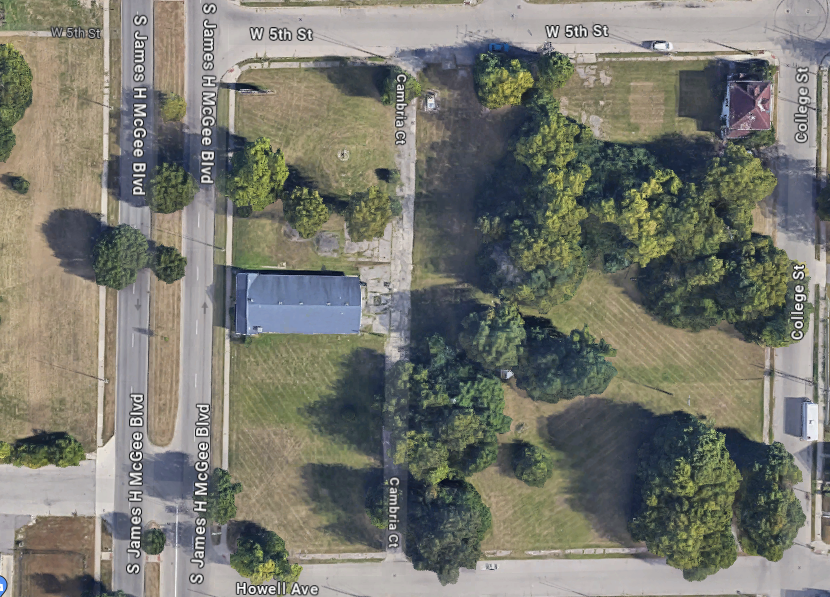
With city neighborhoods struggling to keep and attract residents, it’s also worth remembering that the road project also shrank those neighborhoods directly. Just a 1.4 mile stretch of the multi-part 35 extension took out 283 residences, 17 businesses and even 5 nonprofit organizations.
Like the highway, wide roads built for the purpose of moving cars through also disconnect communities.
As for James H McGee Boulevard, it’s telling that just one year after the new road opened, a rash of traffic accidents forced officials to add a new traffic signal. At the time Dayton’s traffic engineer said “the main problem was the speed on McGee” and that the “wide-open nature of McGee tempts drivers to go faster than 35 mph.”
Today, the consensus is increasingly shifting away from road widening projects which create unsafe conditions in neighborhoods and many argue even make traffic worse. Roadway configurations or “Road Diets“ on the other hand, often reduce the number of lanes in order to “improve safety, calm traffic, provide better mobility and access for all road users, and enhance overall quality of life” including helping people “engage with their neighbors and community,” all major goals of plans to reinvigorate these West Dayton neighborhoods.
In west and northwest Dayton, Salem Ave and West Third Street have both recently been reconfigured for safety and accessibility. (And in other parts of Dayton like Wayne Ave, high speeds and tragic crashes are spurring calls for action.)
The intent of this article is not to delve deeply into street design debates, but reflecting on the goals of roads vs. streets and their impacts on neighborhoods is a compelling topic. The calculus is also different for separated boulevards like James H. McGee, but the concepts are still central when they cut through neighborhoods.
Even more ambitious are highway removal plans, which have been successfully implemented in many cities and some have called for one for parts of 35 in Dayton.
To sum things up, it’s interesting that McGee himself opposed the construction of Interstate 675 before it was built, and it only moved forward after he left office when new mayor Paul Leonard cast the deciding third “Yes” vote.
McGee later said “You can see what 675 did to downtown. That’s what highways like that can do: They suck the vitality out of a city.”
Additional Sources
Cars Roll on 35 West Section, Dayton Daily News, 7/2/1991
Accidents Signal Need for Safer Intersection, Dayton Daily News, 1/22/1992
Communities Link Hopes to 35 West, Connector, Dayton Daily News, 3/17/1990
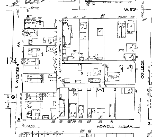
Sanborn Fire Insurance Maps


")
My family lived in an apartment building at 441 N. Western Avenue in 1953. Across the street from our building was Sucher’s Park where they had open air wrestling. I was very young, but I thoroughly enjoyed exploring the neighborhood with my little brother. There were no helicopter moms in those days!
Oh wow, thanks for sharing! I’m sure that was a fun experience to get to explore the neighborhood as it was then as a child. I wish I could’ve been able to see so many of these areas of Dayton before the highways, widened roads, etc.