
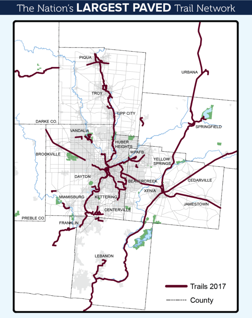
Did you know that Dayton and the Miami Valley region boasts the largest connected paved trail system in the entire country?
In terms of connectivity, it is truly a world class system. Outside of trail systems in progressive and bicycle friendly metros such as Minneapolis, Minnesota, Portland, Oregon, and Washington D.C., there are not many regions in the country with such a built-out and connected system.
What separates this region’s system from other metros is the seamless connectivity of the trails as well as the distance you can go. Within the Miami Valley and the surrounding counties, there are approximately 340 miles of connected and paved off-street trails linking over 40 communities. That is incredible, and the city and region need to market these assets loudly and proudly– not only as recreation and quality of life resources, but as transportation, economic development and tourism drivers as well.
Think of these trails as bicycle highways. From downtown Dayton’s hub at Riverscape, you can get to Yellow Springs, Xenia, Springfield, Miamisburg, Piqua, Troy, Franklin, and even all the way to Cincinnati without virtually ever coming into contact with a car.
Source: MVRPC
Additional link: Full Bike Trail Map from Miami Valley Trails
The tale of the trails in Dayton begins in 1976 when the first eight miles of multi-use paths along the Great Miami River near downtown Dayton were constructed, setting the base for the trail system we have today. Horace Huffman, whose father founded the Huffman Manufacturing Corporation which would become one of the largest producers of bicycles in the world, was the “visionary for Dayton bicycling.”
While president of the Huffy Corporation, Horace advocated for cycling beyond the realm of his boardroom duties. He co-founded the Dayton Cycling Club in 1961, and four years later formed the Greater Dayton Bikeway Committee, later known as the Miami Valley Regional Bicycle Council.
The region’s first bicycle plan was adopted in 1973 and in 1976 the “Original 8” segment (so named for its mileage and officially the Horace M. Huffman River Corridor Bikeway) was built by the Miami Conservancy District, looping along both banks of the Great Miami River north to the confluence of the Stillwater River.
And since that original 8, the system has been built out to a near 340 miles connected mostly along former rail corridors and Miami Conservancy levees. And there are plans to continue to expand.
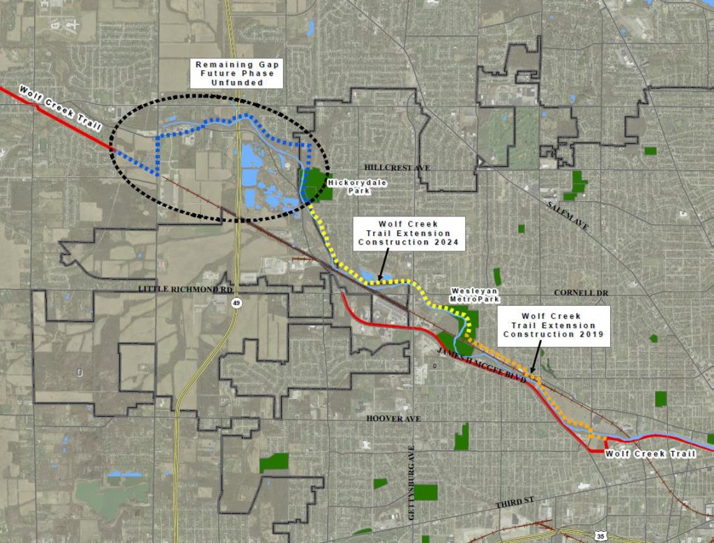
Two major trail projects have been recently proposed including the extension of the Wolf Creek Trail— which would begin to complete the gap between Trotwood and Dayton’s west side along the Wolf Creek, and the Flight Line—an urban rails-to-trails project which would connect downtown Dayton into the Creekside Trail.
The Wolf Creek Trail extension will begin to fill a glaring gap in the regional system. The trail begins at the confluence of the Wolf Creek and Great Miami and traverses along the creek for approximately one mile before becoming a side-use path along James H. McGee. The City of Dayton and Five Rivers MetroParks are partnering to extend the trail along the creek up to Wesleyan MetroPark and then further up to Hickorydale Park, with the ultimate goal to fill the gap to Trotwood, where the trail picks back up again.
Completing this gap is not only important to provide a seamless connected trail another 15 miles to Verona where it currently ends, but to provide the same level-of-service for users in the western half of Dayton and Montgomery County as there is in the eastern half. That extension to Wesleyan MetroPark is expected to be completed in July 2019, while the Wesleyan-Hickorydale connection is expected in 2024. The remaining gap to Trotwood remains unfunded.
One of the unique and potentially transformative opportunities of the project is that the rail spur is elevated at its western terminus, offering great views of downtown Dayton. The project is inspired by similar elevated rails-to-trail projects such as the Chicago 606 project. The Flight Line remains in the visionary stage as the City of Dayton continues to seek funding for acquisition of the corridor, which is currently owned by Norfolk Southern Railway Corp. The city received a small but nonetheless significant boost when it was one of 10 entities nationwide to be awarded a Rails-to-Trails grant in 2018.
Slideshow: Flight Line Map, current view, rendering of proposed trail
However, while Dayton has an elite off-street paved trail system, it’s still playing catch-up to other cities in the on-street infrastructure that allows for safer connections and linkages between neighborhoods and the existing trails.
But that is changing. As of 2014, only 3.5 miles of bike lanes and 1.5 miles of shared lane markings existed on city streets. Today, a total of 20.1 miles of bike lanes and 11.7 miles of shared lane markings have been installed, a significant increase. The most notable connection has been connecting the riverfront area in downtown Dayton all the way to the University of Dayton, filling the gap between downtown and UD under US-35.
And more on-street infrastructure is on the way. In the coming years a total of 14.4 miles of new bikes lanes are planned to be installed, with approximately 2 new miles of bike lanes planned for construction in 2019 during roadway reconstruction projects.
As Dayton continues to expand its on-road infrastructure, it should recognize that the trail system is an asset that sets the city apart. One of the things that has always been authentic about Dayton and its history is the bike culture. From the Wright Brothers bicycle business, to the Huffy Corporation, to its world class trail system, the bicycle is an important element to Dayton’s character. And the regional trail system we have now in the Miami Valley is what other regions and metros throughout the country can only aspire to for their future.
You can follow Jon on Twitter at jonwhite17


Leave a Reply