• Skip to primary navigation
  • Skip to main content
  • Skip to primary sidebar

Dayton Vistas

A Look at the Past, Present, and Future of the Gem City

Connect with Dayton Vistas

  • Bluesky
  • Facebook
  • Instagram
  • TikTok
  • Twitter
  • YouTube
  • Home
  • About
  • Contact
  • Hire Me
    • Dayton History Presentations
    • Walking Tours
    • House and Building Histories
  • Browse Articles
  • Catalog of Historic Dayton Buildings
  • My Dayton Book

Map of the 1913 Great Flood: How Much of Dayton Was Underwater?

March 26, 2021 By Andrew Walsh Leave a Comment


On this date in 1913, the Great Flood was in full swing in Dayton.

On Tuesday, March 25, continuing heavy rains caused the levees to burst and send torrents of water into the central business district.

The following day, Wednesday March 26, the floodwaters crested in Dayton and downtown also suffered from the gas explosion and fires that are the inspiration for the name of the Fire Blocks district.

The flood led to lives lost (over 360 people), property destroyed (about 20,000 homes), and it also damaged a large percentage of the landmarks I cover in my book Lost Dayton, Ohio, sites both downtown and in the surrounding neighborhoods.

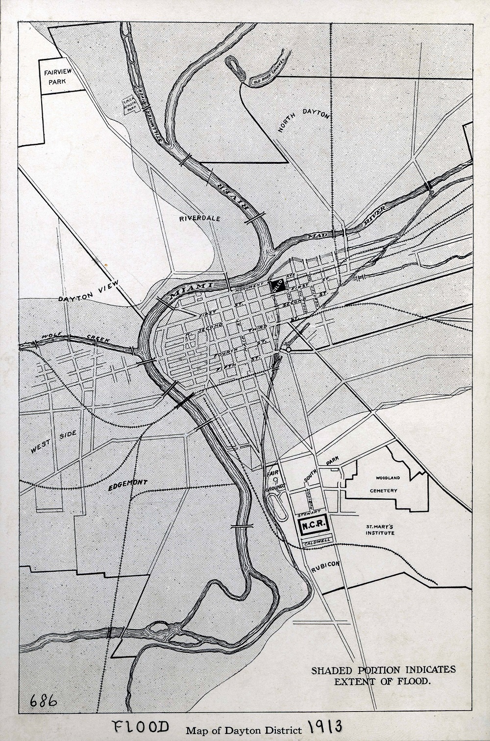
One question I’ve often received at my book talks is how much of Dayton was underwater during the great flood.

In several locations the waters reached 20 feet deep early on March 26th, and the average downtown was over 10 feet. But it extended far beyond the central business district, as over half of the city was flooded by waters at least 3 feet deep.

The following image paints a picture of just how far the waters reached.

dayton flood map

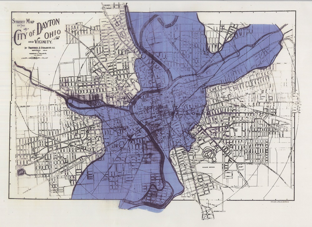
Here’s another view that shows a larger map area with the flooded sections outlined.

dayton flood 1913 map


More Photos of the Great Flood of 1913 in Dayton

dayton flood 1913 looking toward riverdale
This image is taken from the NW of downtown looking out over Riverdale and McPherson Town. Steele High School (and downtown behind it) is visible at top right.
This photo looks west across the Great Miami from NCR into the Edgemont neighborhood
This photo is looking west from Fifth and Eagle streets (in the lost Haymarket neighborhood in between the Oregon District and St. Anne’s Hill). Steeple in background at right is Holy Trinity Catholic Church. This location’s distance from downtown helps demonstrate the extent of the flooding and how far out it spread.
Hundreds of rescue boats set out to rescue stranded Daytonians in the aftermath of the flood. In this image see the high water mark on the homes that shows how dangerous a situation the flood peak was for so many areas in Dayton.

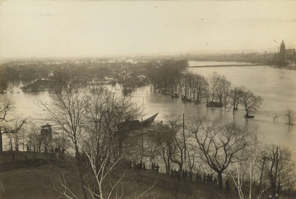
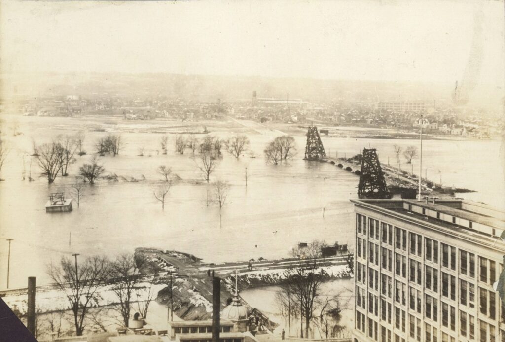
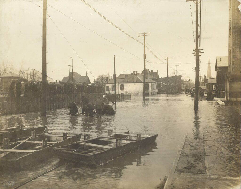
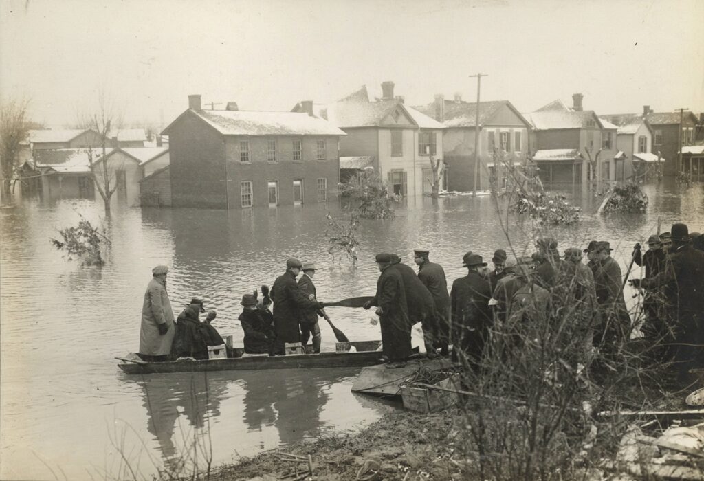
All flood images are courtesy of Dayton Metro Library

Related Posts:

  • mclantern_5_full
    How Did the Great Flood Affect Dayton Businesses?
  • east third from st clair
    The Oldest Commercial Buildings Downtown (Which…
  • Then and Now: 124 East Third Street in the Fire Blocks
    Then and Now: 124 East Third Street in the Fire Blocks
  • Dayton Bicycle Club Edwin Smith House
    History of the Edwin Smith House (Dayton Bicycle Club)
Enjoying Dayton Vistas?
Take a look at Andrew's book Lost Dayton, Ohio. You can also subscribe to our newsletter for periodic updates of new articles.

Filed Under: Historical Dayton Tagged With: Great Flood of 1913, Old Dayton Maps

Reader Interactions

Leave a Reply Cancel reply

Your email address will not be published. Required fields are marked *

Primary Sidebar

Search the Dayton Vistas Archives

My book explores a diverse selection of retail, industrial, entertainment and residential sites from Dayton's disappearing legacy.
Read More

About Dayton Vistas

I'm Andrew Walsh and I research Dayton history, architecture, preservation, and urban redevelopment. In addition to my writing, I give talks and walking tours.

Read More

Get New Posts via Email


Latest Posts

1731 Philadelphia Drive College Hill Dayton View

History of 1731 Philadelphia, “Home Beautiful” in Upper Dayton View

wright dunbar new townhomes simms

Wright Dunbar Townhomes: New Market-Rate Housing for West Dayton

901 keowee st

Award-Winning Architecture at the Corner of Keowee and Webster

historic building at washington and longworth dayton

Midtown Survivors at Washington and Longworth

historic view of east side of main street, downtown dayton

Urban Renewal and Lost Buildings at Main and 3rd

heritage coffeeshop university of dayton built 1903

Lesser-Known Historic Buildings of the University of Dayton

Browse Historic Dayton

newcom tavern daytonA Catalog of Historic Dayton Buildings (with years, pics, type, area, status, etc.)

Recent Comments

  • Mollie Hauser on The Last Old Buildings on the West Side of Downtown
  • William "Rusty" Pietrzak on The Diner on St. Clair: a History and an Uncertain Future
  • Laura J Merrell on Historic Buildings on the University of Dayton Campus
  • Накрутка мобильными on Lost Commercial Buildings at Main and Franklin

Articles By Topic

Architecture Banking Brown Street Churches Commercial Building Dayton Arcade Dayton Culture Dayton Daily News Delco Demolition Downtown East Dayton Features Fidelity Building Fire Blocks District Great Flood of 1913 Historic House Histories Huffman Industrial Buildings John H Patterson Museums NCR Old Dayton Maps Old North Dayton Oregon District Paul Laurence Dunbar Preservation Rare Dayton Photos Restaurants Retail Rike's Sanborn Maps South Park Sports St. Anne's Hill Then and Now Twin Towers University of Dayton Urban Planning Urban Renewal Wayne Avenue West Dayton Windsor Companies Wright-Dunbar Wright Brothers

Copyright © 2025 · News Pro On Genesis Framework · Affiliate Disclosure and Privacy Policy · WordPress · Log in