That Dayton once had a canal run directly through it is no secret. There are even several remaining references to this unique chapter in history, such as the park-like Canal Walk near the ballpark and Canal Street Arcade and Deli across the street.
But some details about the canal aren’t as widely known, like how exactly it was used on a daily basis, the conditions which led to its growth and decline, as well as the massive impact it had on the city of Dayton.
Let’s dig into its history with a few images to help tell the tale.
When Did the Miami and Erie Canal Come to Dayton?
The canal arrived in Dayton in 1829. When completed in 1845 at a cost of over $8 million, the Miami and Erie Canal connected Lake Erie in Toledo to the Ohio River in Cincinnati, giving farmers and merchants a much more efficient way to transport their wares to larger communities.
At the time, roads were an unreliable slog and rivers were also inefficient.
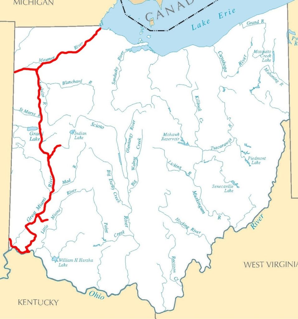
Below you can see the overall path of the canal through Ohio.
The canal enjoyed its heyday in the decades leading up to 1850, as explained by John Gower: “Dayton was a major international port for goods coming into Ohio. That spurred explosive growth. Without the canal, Dayton today would probably be the size of Germantown (population 5,547).”
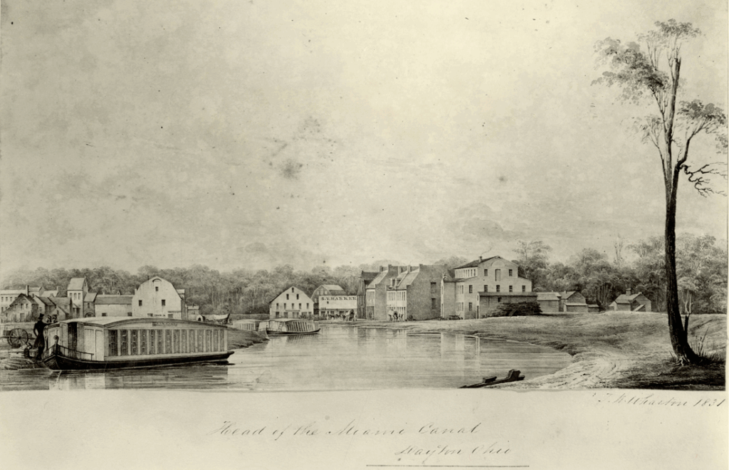
Below is a 1831 watercolor by Thomas K. Wharton titled “Head of the Miami Canal in Dayton”
A Dayton Daily News history described the new world of commerce made possible by the canal:
“For the first time, ‘finished goods’ from Cincinnati could be purchased in Dayton. Line boats, used for hauling freight on the canal, were filled with whiskey, wheat, corn and blocks of ice. Canal boats with names like “Gem of Dayton” and “St. Louis of Dayton,” were pulled by teams of mules or horses along a 10-foot-wide tow path. The animals hauled the 78-foot-long boats for five to six hours before a second team took over to give them a rest.”
It was also a major route for personal transportation, as 7,000 people made the trek from Cincinnati to Dayton in 1831 in special barges featuring large cabins known as “packets.”
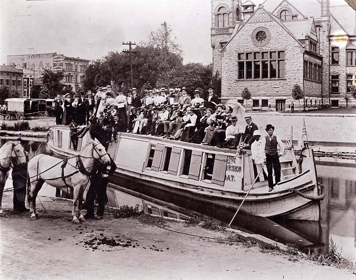
Below is an image of a typical excursion on the canal in 1898. It depicts students from Steele High School on their way to a picnic near Taylorsville nine miles away.
Decline of the Miami and Erie Canal
Despite all of the success the canal enjoyed during its early years, its days were be numbered as a more efficient form of transportation soon emerged: rail travel. By 1860, Ohio had 2,946 miles of railroad lines, “more than three times the miles of all the state canals.”
Because it had been usurped by the new “electric mule,” the canal was mostly abandoned by the late 1800s, and the 1913 flood was its “death blow.”
It sat unused for years, until it was filled in in 1927. Today Patterson Boulevard follows the path of the old canal.
But let’s look at a couple more historic images from the canal years. This one features elephants bathing in the canal during a celebration in 1899.
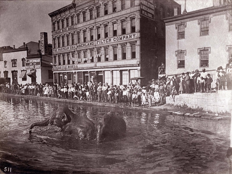
These buildings are long gone, but where is this location today?
To find out, we can use one of the businesses prominent in the image, the Pasteur Chamberland Filter Company.
A little research reveals that company was located at 61 Wyandot (Wyandotte) Street, producing a water filter that prevented Daytonians “from drinking muddy, polluted and warm water,” according to an 1889 advertisement.
The ad continued to extol the filter’s virtues: “All risk of contracting typhoid fever, diphtheria, dysentery and other zymotic diseases is entirely obviated. From the faucet of the Pasteur Perfection Filter and Cooler flows forth a stream of pure, sparkling and cool water, free from all germs of disease, and all organic matter held in suspension” (Dalton).
You can see the location of Pasteur-Chamberland in the image below, with the canal to the left and East Third Street at the top as a point of reference.
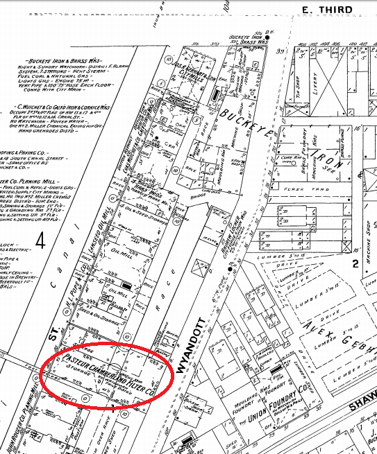
Skipping ahead to the present day, we find that this location is almost directly across the street from the Warped Wing brewery. (Warped Wing’s building, formerly home to the Buckeye Iron and Glassworks Foundry, wasn’t built until 1938 so isn’t in the old map.)
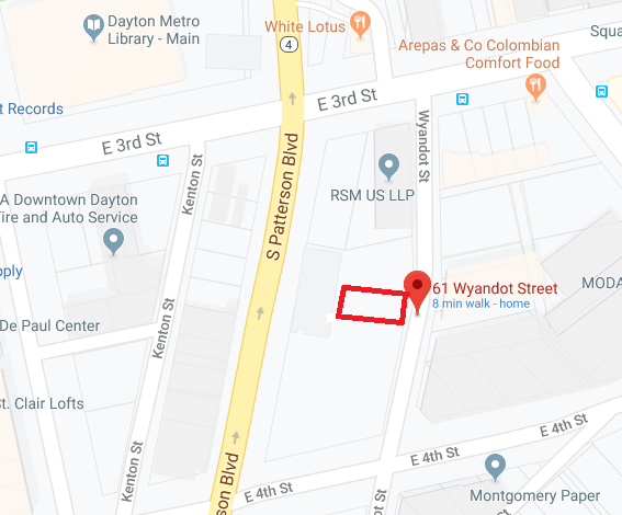
After decades as a surface lot, the space with the buildings in the elephant image is now occupied by the City View condominiums.
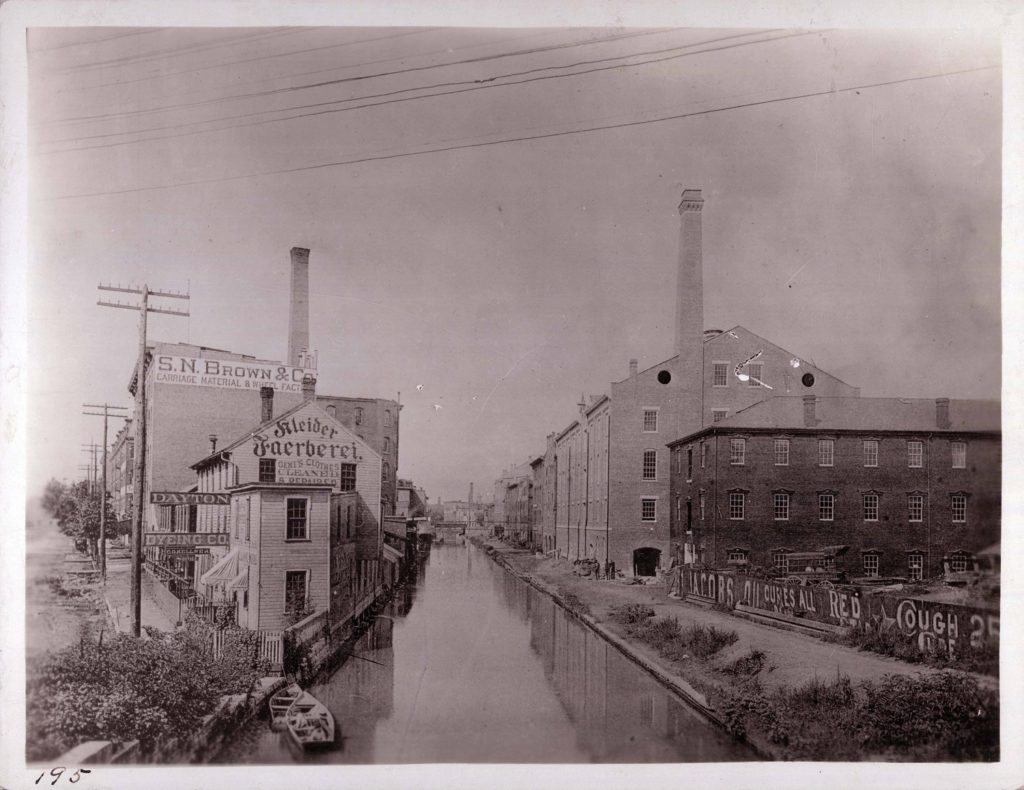
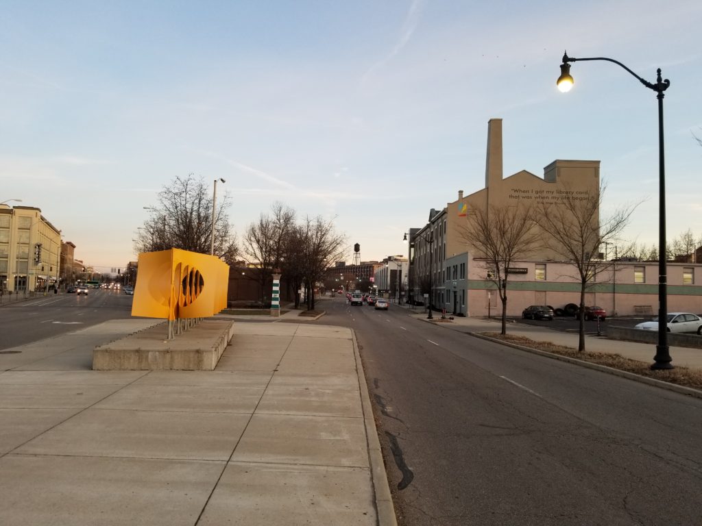
Traveling just a short distance south from this location, we find a canal building that does still stand, the Sachs-Pruden Brewing Company building, which later became Hauer Music and is today the operations center for the Dayton Metro Library. It is visible in this historical image:
And a contemporary one:
Another surviving building that once lined the canal is the Armory Building at 6th and Patterson.
Sources
Historical photos courtesy of Dayton Metro Library


")
A bit disappointed that the section of canal I was interested in viewing isn’t on the Dayton map, an old gentleman named Chappie (in his 80s during the early 1970s) , had told me that the canal, running what through then (the 1970s) was.a very wide ally approximately the width of the old canal, had existed between what is now E. 2nd street to the south, Crane Street to the North, and Harshman street in the East and Beckle.street to the West….Another somewhat related item I am interested in, is the place debris was dumped and covered possibly after the flood of 1913, because during the 1980s when the City or Railroad was putting in a railroad overpass (as a young bottle seeker) I had dug in the side of the hill where it was being installed and recovered an late 1800s Milk bottle from the Linden Ave Dairy company, a.cocked and loaded flint lock pistol, and a wagon wheel, but next day the area was covered over before I could seek more items or information. I suspect this was some debris from the flood of 1913 but am not aware of how to verify that .Thank you very much
My grandfather who was born circa 1895 was present as a boy when these ‘celebrations’ would have elephants bathe in the canal. A story he told me in the mid 80s before he passed away. He was also around when they dredged out the canals and filled them in – saying that the most horrid mutated things were scooped out of that polluted muck.
I was pleasantly surprised to see that image with the elephants and the crowd, thinking my grandfather (as a child) might very well have been in that picture in 1899.