Out of all of Dayton’s main urban streets, Brown Street has perhaps the most interesting history.
Many other prominent city streets remain the way they were originally laid out, while others (or large parts of them) were wiped off the map completely during urban renewal and highway construction.
Brown Street, on the other hand, is still a major business street for Dayton, but it has seen extreme transformation over the years.
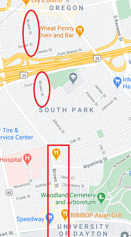
Originally a major thoroughfare running uninterrupted all the way to the Oregon District from the southern edges of Dayton, the construction of US-35 and other urban renewal projects split it up.
So today we actually have three Brown Streets: the small stretch in the Oregon District; another small one on the other side of 35; and then the most familiar one adjacent to the University of Dayton’s campus that is lined with restaurants and shops.
Instead of connecting to the others, the “main” Brown Street by UD now ends when the road veers to the northwest to become Warren Street.
Because of this transformation, as well as other changes due to the growth of the University of Dayton just to the east, many of Brown Street’s historic buildings have been demolished.
But there are still a few gems remaining, if you know where to look.
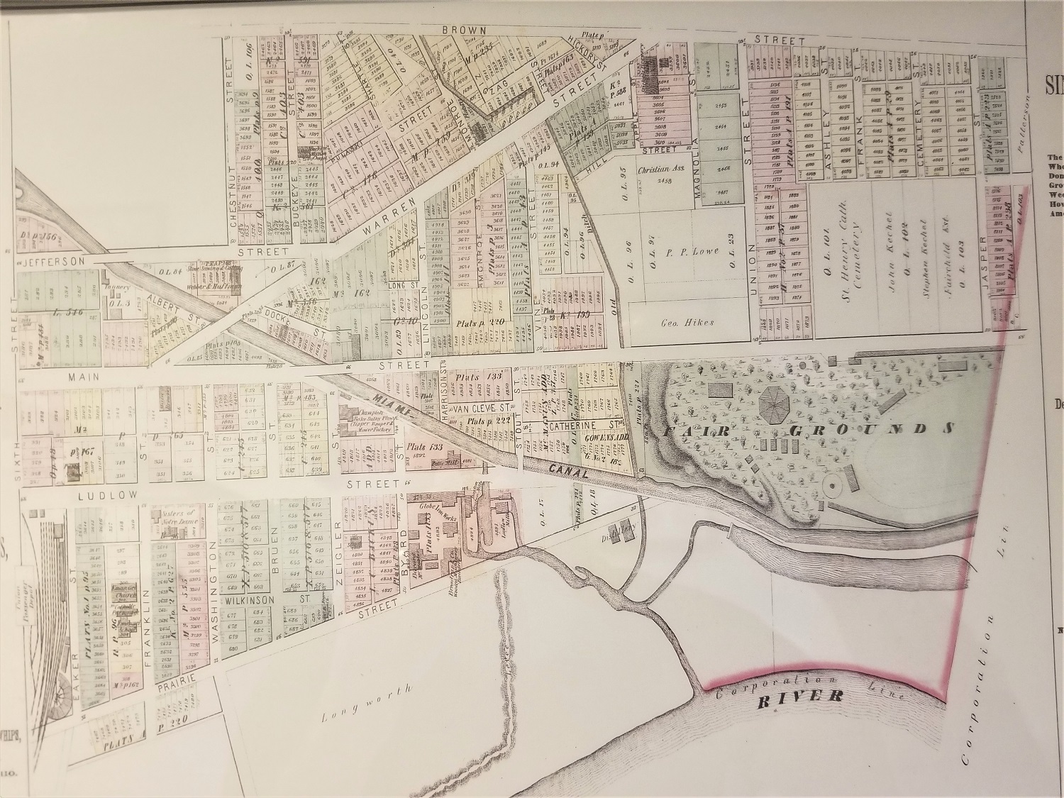
A Glimpse of Old Brown Street (Historic Map)
Remaining Historic Buildings on Brown Street
South Business Cluster/Patterson Homestead
The section of Brown that lies farthest south (before becoming Oakwood Ave as it enters Oakwood) cuts through what was once land owned by the Patterson family known as Rubicon Farm.
The Patterson Homestead was built circa 1816 and gradually the land around it shrank as the city grew and development increased.
Brown Street was significant in that two of Dayton’s most important institutions grew on either side of it. National Cash Register (NCR), Dayton’s most important company throughout most of its 150-year history in the Gem City, built its corporate campus in between Main and Brown Streets just south of Stewart.
And the University of Dayton grew steadily in the early decades of the 20th century just to the east of Brown Street, making it an important thoroughfare.
Most of the buildings in the small business cluster just to the north of Irving Ave were constructed in the early 1900s.
You can read our articles on them below:
Art Frame Gallery (the oldest which dates to the late 1800s)
1900 Brown Street (King’s Market, Buffalo Wild Wings)
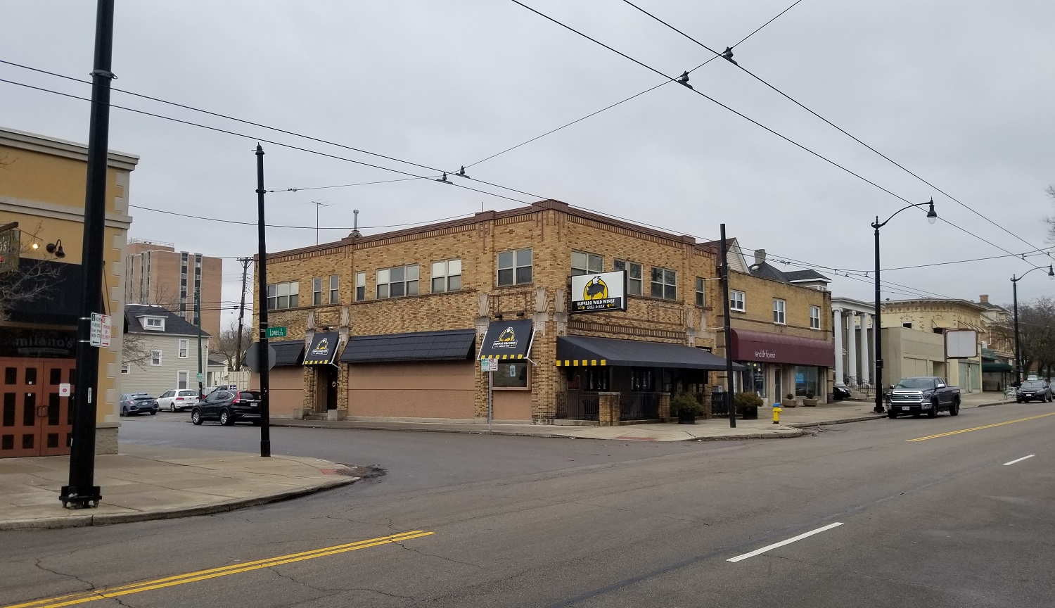
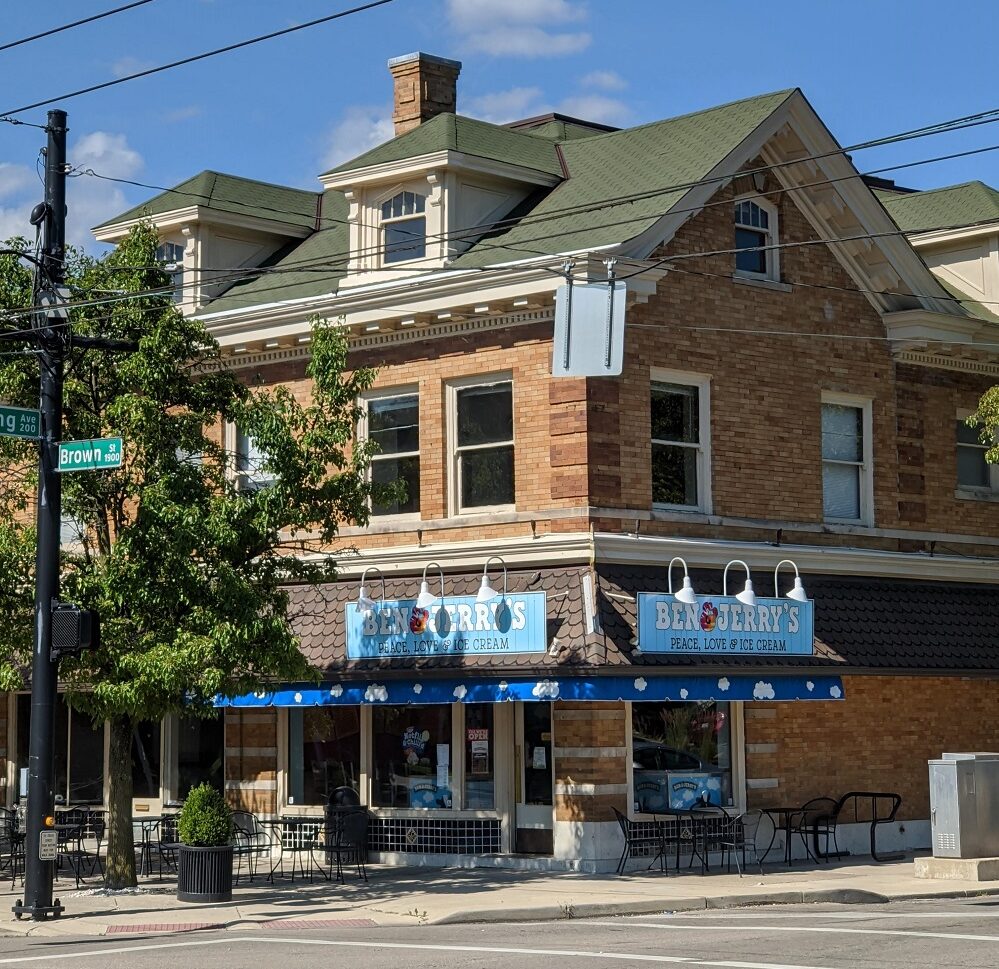
The structure that today houses Ben & Jerry’s on the corner of Brown and Irving dates back to 1908 when it was the Kid Tullis Saloon. Four years later the Rubicon Pharmacy, operated by James W. Smyers, opened in the building’s other storefront.
North Business Cluster
Heading north past the first business cluster, there are several blocks taken up by surface parking, newer apartment structures, and a row of old houses now occupied by students.
When we hit Stewart Street we encounter the second business district adjacent to the university. Much is newer infill development but some historic buildings remain in the next few blocks. We detail some of them here:
1043 Brown St (Bourbon St. Grill/Harshbarger’s): (1905) Harshbarger’s was a grocery store, including live chickens you could choose from. The business did not survive the Great Depression, however. Fortunately, the building has survived, and today it houses the Bourbon Street Grill & Cafe.
1082 Brown St (South End Pharmacy): (1895) The South End Pharmacy opened in 1895, and its neighbor at the time was Harry Oswald’s saloon. The Hickory BBQ opened up in 1962.
1133 Brown Street (Second Time Around): (1929). Elton Slade, who worked his way up to owner of the South End Pharmacy in the previous building, built this structure in 1929 so he could expand his pharmacy. It has been Second Time Around since 1976.
1141 Brown Street was Finley’s garage as of 1926. In 1932 there was an injunction filed against the operation of a pool and card room. It was a store owned by Sam Starry in 1934 and for a time it was next to a Kroger grocery store.
The original structures that today house the Butter Cafe and the Day Yoga studio also date to the 19th century. We will be doing more research on these and other structures and will update this page when we have more information to share.
There is one more historic building to cover to the north of Wyoming Street:
Jimmy’s Ladder 11 (1892) This is a former firehouse dating back to 1892. It’s thought to be “one of the last Dayton firehouses to use a horse drawn apparatus.” It remained in use until a new firehouse opened farther up on Warren Street in 1987. The structure was carefully renovated into the Jimmy’s Ladder restaurant, with many historic details remaining. Unfortunately, everything around it has met the bulldozer at some point over the last few decades, with one beautiful building just having been demolished in early 2021.
The middle stretch of Brown Street, north of the university and south of the highway, has some historic homes remaining but also stretches of vacant lots and abandoned structures.
The north section of Brown Street, in the Oregon District, is well preserved. However, the business potential of the street has been greatly diminished now that it dead-ends into the highway. Thus, the few commercial buildings on that stretch have either been converted to residential or house professional offices that do not require foot traffic.


Thanks so much for posting this information and historic map. Has any consideration been given to reconnecting the two segments of Brown Street south of US35 as new infill projects are being evaluated for that “gap” area in South Park? Even reconnecting them as a pedestrian/bike-only path might help to improve accessibility and walkability in the neighborhood.
Hi Brett, good question! I haven’t heard anything about that but I definitely like the idea. I know they are starting to build the “Flats at South Park” phase two building around there, and I believe some condos after that. Not sure how much the footprint of those projects will cut across the original Brown St. path but it would be great if they could have some sort of walking/bike path in between.
Andrew, nice article. I enjoyed the map; is it available online, or as a hard copy somewhere. Do you know if there’s an inventory of the historic maps of Dayton?
This particular map is a photo of a printed version I got from Carillon Park! For the most part I use the Sanborn map collections which are pretty comprehensive, but I know there are a lot of others out there and I’m not aware of any overall inventory or bibliography of them.
Split streets are an intriguing human conundrum! Our area is not immune, I remember Chicago has a cluster of confusing split streets!
I was always amazed being in the Oregon District at the old Southern Belle across from the small park, that is was cut off from the rest of Brown St.
I remember watching New Germany Trebein split off from its original location by I-675 and later renamed Paragon to fit with the mall.
Many other split streets come to mind such as the curiously named Stop 8 Road in Northridge and the 3 versions of Beatrice St. in Riverside.
West Riverview Ave is my nominee that has the be the most confusing and fascinating split street in the area! It starts off innocently westward from North Main after the bridge over the Great Miami River. Pass Habitat for Humanity it merges as a thoroughfare with the Great Miami Blvd and further Edwin C. Moses where it graces the magnificent Dayton Art Institute and the Masonic Lodge.
I do wonder if DAI’s original address was actually on Riverview?
After Salem Ave. it veers westward and now parallels with Wolf Creek from the 900 to the 2000 blocks where it remains a major east-west thoroughfare ending seemingly at Philadelphia Ave.
Then it gets weird.
The 3000 blocks of West Riverview are tucked away behind a residential neighborhood in the Cornell Heights area. Cut down Shaftsberry or Wesleyan to connect to rows of apartments abutting the creek. This portion of West Riverview ends unceremoniously in Wesleyan Metro Park.
The 4000 blocks of West Riverview are even more desolate.
You have to travel down Cornell and cross Gettysburg to crisis cross through a maze of other split streets such as Blueberry and Kings Hwy for access (which isn’t an actual Highway! Possibly a religious nod!) to find it.
It resembles more of an alley than a regular street at this time.
The 5000 blocks of West Riverview are the fourth incarnation and even more remote. Take Hickorydale over to Queens and it resembles another alley before ending practically in Wolf Creek at the end of Prescott. An old school used to be located here. Wolf Creek Pike is only a few yards away on the other side possibly where the final destination was originally planned.
I am not certain why there are so many versions of West Riverview but it’s very fascinating.
What’s even more trippy is why is it West? Shouldn’t there be an East Riverview???
To top off Riverview Ave as the most notorious split street in Ohio – East Riverview still exists!
Just buried under newer buildings off North Main St. such as the metal 2 Riverplace and the defunct 4 Riverplace.
57 East Riverview lives on as that stand-alone apartment located on a mere walkway across from downtown! The new Montessori school covers the rest of East Riverview where it would have met Riverside Dr.!
Paved over for progress!
https://www.apartments.com/57-e-riverview-ave-dayton-oh/87m28v3/
Try finding that by GPS!
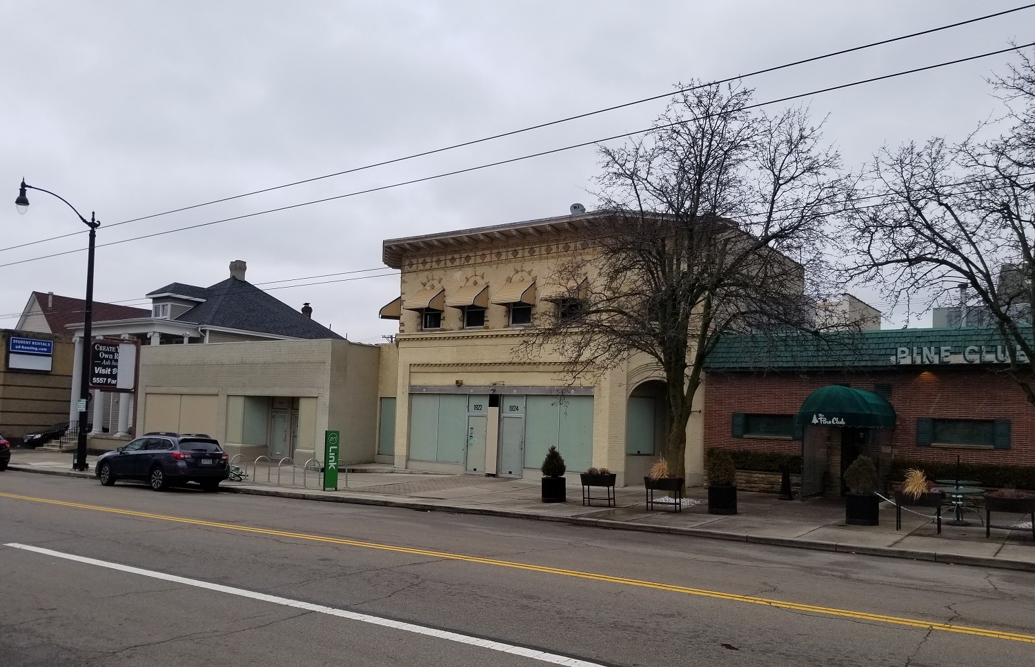
Wish your article included a little Pine Club mention.
You know, you’re right; it should mention it! The section on the business area on the south end of Brown mostly just links to my previous articles about some of the other buildings on the block which I wrote for various reasons. But I should definitely do one on the Pine Club building soon so that it’s more complete!