Located at the edge of Dayton's Oregon District, the Belle of Dayton distillery has a fascinating history not only for its location, which has housed a wide range of tenants over the years, but also for the story of the Belle of Dayton brand which takes us all the way back … [Read more...] about Belle of Dayton: A Distillery with a Prohibition-Era Connection
Sanborn Maps
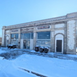
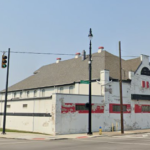
The History and Architecture of 1922 and 1918 Brown Street
A pair of interesting buildings on Brown Street forms part of one of the more intact blocks of neighborhood commercial structures in Dayton, and also help tell the story of the surrounding area. Recently these buildings were sold, and online posts have advertised the … [Read more...] about The History and Architecture of 1922 and 1918 Brown Street
Lost Commercial Buildings at Main and Franklin (Genuine Auto Parts)

In a recent article I showed a Then and Now of South Main and Franklin where a 1920s auto building has been transformed into a medical facility. On the other side of Franklin at the SW corner of the intersection, unfortunately, we have a different story with a great block … [Read more...] about Lost Commercial Buildings at Main and Franklin (Genuine Auto Parts)
Bommy’s Bar, Dayton’s First Apartments, and Riverview Park
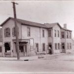
The image above depicts a popular saloon known as "Bommy's Place" that once stood off of Salem Ave just across the Great Miami River in Dayton View. It was owned by Fred Bomhard who opened it in 1896. The establishment was known as "one of the best-known and most popular … [Read more...] about Bommy’s Bar, Dayton’s First Apartments, and Riverview Park
Canal at 2nd Street Then and Now
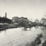
I've previously written a history of the Miami and Erie canal in Dayton that included a then and now photo of an 1899 celebration that included two elephants bathing in the canal. In that post I used a visible business and map to determine where that location is … [Read more...] about Canal at 2nd Street Then and Now
The Todd Art (Sigma) Theater and a Lost Brown Street Business District
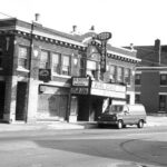
The old firehouse currently home to Jimmy's Ladder 11 restaurant on Brown Street is a beautiful but isolated survivor of what was once a thriving neighborhood business district. One of its most significant neighbors was an old theater located at 924 Brown Street. Built … [Read more...] about The Todd Art (Sigma) Theater and a Lost Brown Street Business District
James H McGee Boulevard History: Road Widenings, 35 West, and Neighborhoods
In my last article on the Bowers Building on West Third Street, I mentioned how James H McGee Boulevard was originally created as a widening of what had been Western Ave. As it turns out, that is an interesting story in its own right which I'll dig into today. James H. … [Read more...] about James H McGee Boulevard History: Road Widenings, 35 West, and Neighborhoods
The Steamboat House in St. Anne’s Hill (Rare Photo)
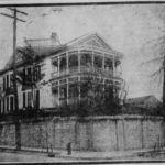
Today's article came about rather serendipitously, as I was researching something unrelated only to come across a striking image of a home for sale in the Dayton Daily News on April 21, 1918. After only a quick glance it was obvious which house it was, as it is one of the … [Read more...] about The Steamboat House in St. Anne’s Hill (Rare Photo)
History of the Oscar Gottschall House
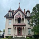
The beautiful building at 20 Livingston Ave, just off of Huffman Ave, is known as the Oscar M. Gottschall house. It was built c. 1870 for Gottschall, a prominent Dayton attorney, and his wife Octavia Soule who were married in 1869. It's an unusual building which … [Read more...] about History of the Oscar Gottschall House
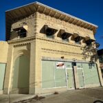
History of the United Business Services (UBS) Building
I recently published an article about Woodard Development's foray into the Oregon District. Today I'll cover the history of another building they purchased just on the edge of the historic neighborhood. The former United Business Services (UBS) Building is located at … [Read more...] about History of the United Business Services (UBS) Building