• Skip to primary navigation
  • Skip to main content
  • Skip to primary sidebar

Dayton Vistas

A Look at the Past, Present, and Future of the Gem City

Connect with Dayton Vistas

  • Bluesky
  • Email
  • Facebook
  • Instagram
  • RSS
  • TikTok
  • Twitter
  • YouTube
  • Home
  • About
  • Contact
  • Hire Me
  • Categories
    • Historical Dayton
    • New Developments
    • Dayton Culture
  • Article Archives
  • Catalog of Historic Dayton Buildings
  • My Dayton Book

Canal at 2nd Street Then and Now

August 16, 2024 By Andrew Walsh 1 Comment


I’ve previously written a history of the Miami and Erie canal in Dayton that included a then and now photo of an 1899 celebration that included two elephants bathing in the canal. In that post I used a visible business and map to determine where that location is today.

This article will do a similar investigation of an old canal photo I recently came across:

Photo courtesy of Dayton Metro Library

The image is titled “Canal at Second Street” from 1903. At first glance it wasn’t immediately apparent which direction the photo is facing. But a few clues from the photo caption can help us figure it out.

The business that can be identified is the George J. Roberts Company, which was located at the northwest corner of Second and Mill Streets.

The other major clue is that the park visible on the left side of the photo is identified as the “Library Park” which we can understand to mean Cooper Park behind the downtown library.

That lets us know that the old photo is facing north, but especially since Mill Street no longer exists, it’s a good idea to pull up Sanborn Maps of the area to better understand the orientation.

In the following image I stitched together 2 maps so we can see the George J. Roberts Co is located (circled in red) as well as the library park.

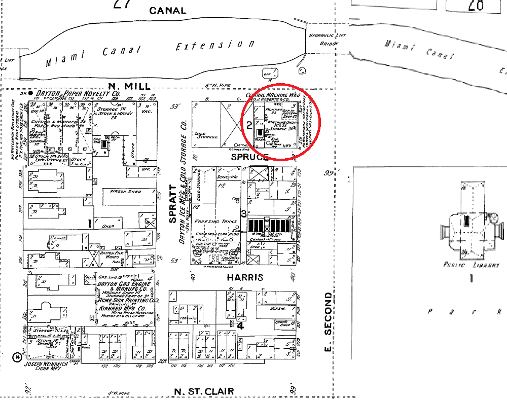
(I also have written a history about the building at the corner of Spratt and Harris in the image, the Dayton Ice Manufacturing and Cold Storage Co.)

Now we can compare the historic photo to a present-day image:

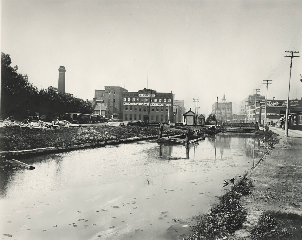
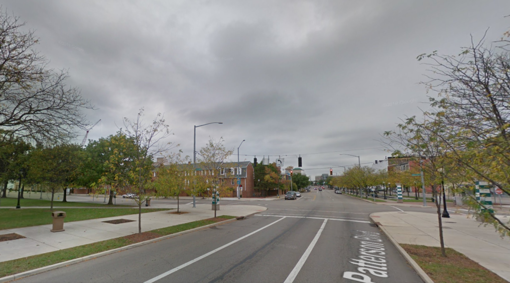
This area would change radically in the decades after this picture was taken. The canal, already pretty dilapidated by 1903 as can be seen, was given its death blow a decade later by the Great Flood.
The building of the George J. Roberts Company and surrounding area was largely turned in to parking lots for Delco employees as that company moved nearby just after the flood and grew into an industrial behemoth.

Only more recently did that land get filled back in with the condo buildings, and now this is the fastest-growing area of downtown with major hotel, apartment, and other mixed-use development projects in recent years, including Delco’s first and second factories.

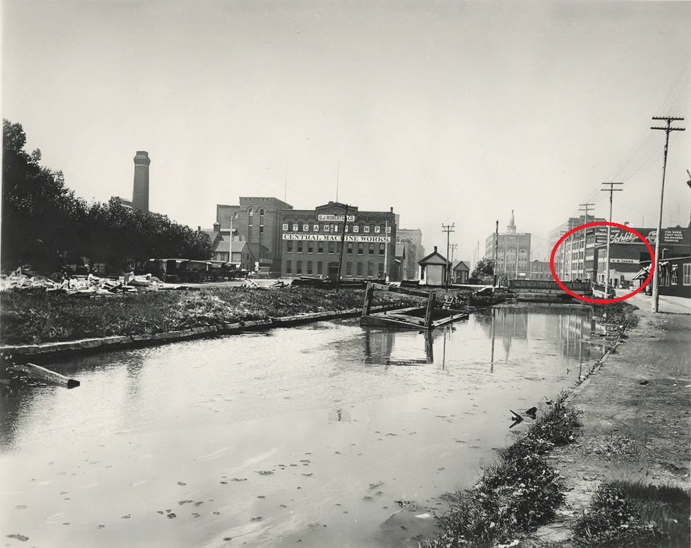
The majority of the structures present in the historic image are of course long gone today, but if you look closely you can identify a group of canal buildings that survive to the right of the image (although they’re a bit obscured by trees in the modern-day image).

These include industrial structures that once held tenants like A. N. Nixon’s Tobacco Warehouse and today house Canal St. Arcade and Deli and its neighbors, and the former canal depot building which was used for received and shipped merchandise traveling on the canal and is today DECA Middle School. See those old canal buildings in more detail.

Related Posts:

  • street carnival dayton elephant canal
    Miami & Erie Canal History: When and Where was…
  • dayton canal buildings webster station
    Then and Now: Canal Buildings in Webster Station
  • A Trip from Dayton to Cincinnati (in 1818)
    A Trip from Dayton to Cincinnati (in 1818)
  • ubs-building
    History of the United Business Services (UBS) Building
Enjoying Dayton Vistas?
Take a look at Andrew's book Lost Dayton, Ohio. You can also subscribe to our newsletter for periodic updates of new articles.

Filed Under: Historical Dayton Tagged With: Canal St Arcade and Deli, Cooper Park, Delco, George J. Roberts Co, Industrial Buildings, Miami and Erie Canal, Old Dayton Maps, Sanborn Maps

Reader Interactions

Comments

  1. Steve says

    August 25, 2024 at 8:56 pm

    I think you’ve found the right location. However, I think that the George J. Roberts company was on the Southeast corner of N. Mill and 2nd St. (rather than the Northwest corner). I had to rotate your map until Second St ran (mostly E – W) then locate the “Canal Walk” and Library, then compared with Google maps and a map from 1875. The Miami Canal Extension has been replaced by North Patterson Blvd. (Even the angle to the west at Second St.) The street on the 1903 map, called Harris, now appears to have been replaced by Harries. (per Google maps). Would have placed the 1903 photographer’s location South of Second street, just a few yards farther south than the included Google street maps photo and a few yards to the left (In the center or eastern side of North Patterson Blvd)

    Reply

Leave a Reply Cancel reply

Your email address will not be published. Required fields are marked *

Primary Sidebar

Search the Dayton Vistas Archives

My book explores a diverse selection of retail, industrial, entertainment and residential sites from Dayton's disappearing legacy.
Read More

About Dayton Vistas

I'm Andrew Walsh, a writer and academic librarian. I research Dayton history, architecture, preservation, and urban redevelopment.

Read More

Get New Posts via Email


Latest Posts

901 keowee st

Award-Winning Architecture at the Corner of Keowee and Webster

historic building at washington and longworth dayton

Midtown Survivors at Washington and Longworth

historic view of east side of main street, downtown dayton

Urban Renewal and Lost Buildings at Main and 3rd

heritage coffeeshop university of dayton built 1903

Lesser-Known Historic Buildings of the University of Dayton

dayton masonic temple

Masonic Temple (Dayton Masonic Center) History

dayton commercial building during construction 1900s

The Commercial Building: Before and During Construction

Browse Historic Dayton

newcom tavern daytonA Catalog of Historic Dayton Buildings (with years, pics, type, area, status, etc.)

Recent Comments

  • Mollie Hauser on The Last Old Buildings on the West Side of Downtown
  • William "Rusty" Pietrzak on The Diner on St. Clair: a History and an Uncertain Future
  • Laura J Merrell on Historic Buildings on the University of Dayton Campus
  • Накрутка мобильными on Lost Commercial Buildings at Main and Franklin

Articles By Topic

Architecture Banking Brown Street Churches Commercial Building Dayton Arcade Dayton Daily News Delco Demolition Downtown East Dayton Features Fidelity Building Fire Blocks District Great Flood of 1913 Historic Homes House Histories Huffman Industrial Buildings John H Patterson NCR Old Dayton Maps Old North Dayton Oregon District Paul Laurence Dunbar Preservation Rare Dayton Photos Restaurants Retail Rike's Sanborn Maps Santa Clara South Park Sports St. Anne's Hill Then and Now Twin Towers University of Dayton Urban Planning Urban Renewal Wayne Avenue West Dayton Windsor Companies Wright-Dunbar Wright Brothers

Copyright © 2025 · News Pro On Genesis Framework · Affiliate Disclosure and Privacy Policy · WordPress · Log in