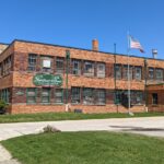
When thinking about business in downtown Dayton, you may picture legal and financial services, upstart tech firms, and perhaps all the jobs at the big players in healthcare and education. But there are a wide variety of companies both large and small that have been … [Read more...] about History of H. Gerstner & Sons, World-Renowned Tool Chest Maker
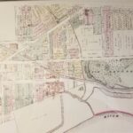
Old Dayton Maps
South Park Food Hall to Open in Historic Wayne Ave Site
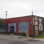
According to information on social media, a new food hall is coming to the Wayne Avenue corridor in historic South Park. The South Park Food Hall will be located at 735 Wayne Ave and is planning to open in Summer 2021. Businesses will include the Good Hands Bread Co, … [Read more...] about South Park Food Hall to Open in Historic Wayne Ave Site
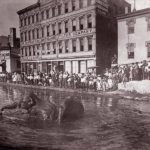
Map of the 1913 Great Flood: How Much of Dayton Was Underwater?
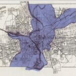
On this date in 1913, the Great Flood was in full swing in Dayton. On Tuesday, March 25, continuing heavy rains caused the levees to burst and send torrents of water into the central business district. The following day, Wednesday March 26, the floodwaters crested in Dayton … [Read more...] about Map of the 1913 Great Flood: How Much of Dayton Was Underwater?
The History and Razing of the Haymarket (The Actual Market)
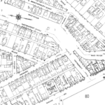
In many of my presentations (and my book Lost Dayton Ohio), I tell the story of the lost Haymarket neighborhood, which was located in between the Oregon District and St. Anne's Hill, and how it met its end. This article will also chronicle the end of the hay market, … [Read more...] about The History and Razing of the Haymarket (The Actual Market)
History of Old and New Brown Street, Split Up by a Freeway
Out of all of Dayton's main urban streets, Brown Street has perhaps the most interesting history. Many other prominent city streets remain the way they were originally laid out, while others (or large parts of them) were wiped off the map completely during urban renewal … [Read more...] about History of Old and New Brown Street, Split Up by a Freeway
History of the Art Frame Gallery at 1652 Brown St.
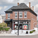
There are a couple of main pockets of old buildings remaining on Brown Street near the campus of the University of Dayton. One is north of Stewart near Woodland and Fairground Ave, while the other is near Irving Ave across from the Patterson Homestead. In the middle of … [Read more...] about History of the Art Frame Gallery at 1652 Brown St.
Miami & Erie Canal History: When and Where Was Dayton’s Canal?
That Dayton once had a canal run directly through it is no secret. There are even several remaining references to this unique chapter in history, such as the park-like Canal Walk near the ballpark and Canal Street Arcade and Deli across the street. But some details about … [Read more...] about Miami & Erie Canal History: When and Where Was Dayton’s Canal?